Indian Residential Schools Interactive Map
Warning!
This page discusses topics that may be distressing and awaken memories of past traumatic experiences and abuse. The National Indian Residential School Crisis Line provides 24-hour crisis support to former Indian Residential School students and their families toll-free at 1-866-925-4419. You can access emotional crisis referral services, and information on how to get other health supports from the Government of Canada, through this toll-free line. First Nations, Inuit and Métis seeking immediate emotional support can contact the Hope for Wellness Help Line toll-free at 1-855-242-3310, or by online chat at hopeforwellness.ca.
The Indian Residential Schools Interactive Map allows users to visualize the location of the 140 former residential school sites recognized in the Indian Residential Schools Settlement Agreement as well as provide information on the current status and historical context of the site. Clicking on the dots provides information about the schools and sites.
At the top left side of the map, you can use the plus and minus buttons to zoom into or out of any location on the map where a school was or, is currently located. You can also use the mouse scroll wheel to perform the same actions if you prefer. There is also a search function. On the top right side of the map, you will see the following tools to help you find and view the information on the map, including: a legend menu; a layer list showing the datasets to view; a basemap gallery to view different backgrounds; a filter tool to filter by residential schools and location; a swipe tool that can be used to compare current and historic images; and a measurement tool to measure the distance between two points on the map. Have questions or need help with the map? Contact us by email at servicesgeomatiques-geomaticsservices@sac-isc.gc.ca.
Static Maps
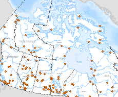
Below you will find links to static maps displaying the location of IRS sites in Canada. The maps are available in the following extents, Canada Wide or for a specific province or territory. They can be downloaded in PDF or PNG formats.
Indian Residential Schools Imagery - Open Data
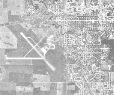
You can access the historical aerial photography for Indian Residential Schools here. This Web Map Service is comprised of digital scans of aerial photographs that were acquired from 1924 to 1998 over residential school sites across Canada, as well as information about each photograph. While only one image per site is available in the Web Map Service layer, other historical aerial photographs for residential school sites can be accessed via this Natural Resources Canada website.
Sources:
- Indigenous Services Canada and Crown-Indigenous Relations and Northern Affairs Canada (Former Indian Residential Schools - Environmental Scan: Status of Sites and Buildings)
- National Center for Truth and Reconciliation
- Orlandini, (2019) "Residential Schools Locations", https://doi.org/10.5683/SP2/FJG5TG
- Parks Canada